Cafe nearby Mist nargila bar
Coronavirus disease (COVID-19) Situation
confirmed cases
2615054
deaths
18057
Serbia
Cafe nearby Mist nargila bar
Mist nargila bar
4, Stojana Protića, Beograd, Grad Beograd, RS Serbia
contacts phone
:
+381 62 1783613
Latitude:
44.7966646
, Longitude:
20.4700217
larger map & directions
read more
nearest Cafe
139 m
Kafe Knjižara
Neimar, Belgrade
Cafe
read more
212 m
Елипса
Rankeova, Beograd
Cafe
read more
212 m
Zubic
4, Rankeova, Beograd
Cafe
read more
293 m
Cafe&Factory8
Katanićeva 22, Beograd
Cafe
read more
293 m
Priča Kafe&Restorančić
Braničevska 19, Beograd
Cafe
read more
306 m
Priča Bar
11000, Braničevska 19, Beograd
Cafe
read more
315 m
Koki
Makenzijeva 66, Belgrade (Vracar)
Cafe
read more
336 m
Pejton Pub
Katanićeva 1, Beograd
Cafe
read more
338 m
Kafeterija
Makenzijeva 81, Beograd
Cafe
read more
423 m
Talija
Nevesinjska 10, Beograd
Cafe
read more
461 m
Padrino
Nevesinjska 6, Beograd
Cafe
read more
492 m
Recoleta
Nevesinjska 21, Beograd
Cafe
read more
501 m
Aviator Coffee Explorer - Cubura
Cara Nikolaja II 42, Beograd
Cafe
read more
555 m
Кафе Арара
Bokeljska 1а, Beograd
Cafe
read more
567 m
Zlatni Vilajet
Максима Горког 37, 11000, Beograd
Cafe
read more
667 m
Igraonica Trešnjica
Anastasa Jovanovića, Beograd
Cafe
read more
672 m
Moment
Topolska 16, Beograd
Cafe
read more
676 m
Cafeteria Moment
Topolska 16, Beograd
Cafe
read more
692 m
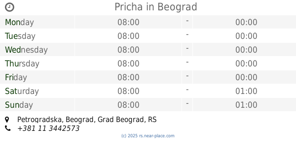
Pricha
Petrogradska, Beograd
Cafe
read more
941 m
GOGEC OFFICE Plan B
Gospodara Vučića 52-56, Beograd
Cafe
read more
960 m
Kafe Dnevna Soba
Kumanovska 14, Beograd
Cafe
read more
967 m
Caffe Bar Eres
Južni bulevar 126, Beograd
Cafe
read more
980 m
Bife Loznicka 8
Loznička 8, Beograd
Cafe
read more
1.016 km
Limbo
Braće Nedić 7, Beograd
Cafe
read more
1.104 km
Coffee Dream
Resavska 78a, Beograd
Cafe
read more
📑
all categories
Accounting
Administrative area level 2
Airport
Amusement park
Aquarium
Art gallery
Atm
Bakery
Bank
Bar
Beauty salon
Bicycle store
Book store
Bowling alley
Bus station
Cafe
Campground
Car dealer
Car rental
Car repair
Car wash
Casino
Cemetery
Church
City hall
Clothing store
Colloquial area
Convenience store
Courthouse
Dentist
Department store
Doctor
Electrician
Electronics store
Embassy
Establishment
Finance
Fire station
Florist
Food
Funeral home
Furniture store
Gas station
General contractor
Grocery or supermarket
Gym
Hair care
Hardware store
Health
Home goods store
Hospital
Insurance agency
Jewelry store
Laundry
Lawyer
Library
Light rail station
Liquor store
Local government office
Locality
Locksmith
Lodging
Meal delivery
Meal takeaway
Mosque
Movie rental
Movie theater
Moving company
Museum
Natural feature
Neighborhood
Night club
Painter
Park
Parking
Pet store
Pharmacy
Physiotherapist
Plumber
Point of interest
Police
Post office
Premise
Real estate agency
Restaurant
Roofing contractor
Rv park, camping
School
Shoe store
Shopping mall
Spa
Stadium
Storage
Store
Supermarket
Synagogue
Taxi stand
Train station
Transit station
Travel agency
University
Veterinary care
Zoo
administrative area level 3
sublocality level 1
↑