Bakery nearby Hleb & Kifle
Serbia
Bakery nearby Hleb & Kifle
Hleb & Kifle
7-9, Crnotravska, Beograd, Grad Beograd, RS Serbia
contacts phone
:
+381
Latitude:
44.7606966
, Longitude:
20.4767043
larger map & directions
read more
nearest Bakery
640 m
Sima
Vojvode Stepe 329, Beograd
Bakery
read more
672 m
Panini
Vojvode Stepe, Beograd
Bakery
read more
679 m
パン屋
Vojvode Stepe 317, Beograd
Bakery
read more
913 m
Hermes
Vojvode Stepe 275, Beograd
Bakery
read more
920 m
Дуо
Vojvode Stepe 275, Beograd
Bakery
read more
931 m
Hleb and Kifle
Vojvode Stepe 264, Beograd
Bakery
read more
1.129 km
Miletova Pekara/Halal Sofra
Vojvode Stepe 236, Beograd
Bakery
read more
1.345 km
Pekara Costa Azzura
Borska, Beograd
Bakery
read more
1.403 km
Pekara Vika
Belgrade
Bakery
read more
1.529 km
Pekara
Jovana Bijelića 10a, Beograd
Bakery
read more
1.657 km
Pekara Kraljica
Vojvode Stepe 85 Beograd 162710, Beograd
Bakery
read more
1.906 km
Omiljena pekara
Belgrade
Bakery
read more
1.908 km
H&M CUPCAKES
Zaplanjska 32, Beograd
Bakery
read more
1.923 km
Poslasticarnica Dessert original Beograd
Jove Ilića, Beograd
Bakery
read more
1.927 km
Andjeli
Banjički Venac, Beograd
Bakery
read more
1.966 km
Dessert original Beograd
Vojvode Stepe 118, Ulaz iz Jove Ilica, Beograd
Bakery
read more
1.97 km
Blagoje
94 Kumodraška, 11010, Beograd (Voždovac), Grad Beograd
Bakery
read more
1.971 km
Pekara Goranac 2
Borska 70, Beograd
Bakery
read more
2.275 km
Hleb & Kifle
Vladimira Gaćinovića 2a, Beograd
Bakery
read more
2.365 km
Roggenart
Vojvode Stepe 74, Beograd
Bakery
read more
2.819 km
Trpković Pekara
Belgrade
Bakery
read more
2.916 km
Pekara Rankovic
Braće Kovač 50, Beograd
Bakery
read more
3.109 km
Pekara Trojka
Miška Kranjca, Beograd
Bakery
read more
3.478 km
Fanico d.o.o
Patrijarha Dimitrija 53, Beograd
Bakery
read more
4.4 km
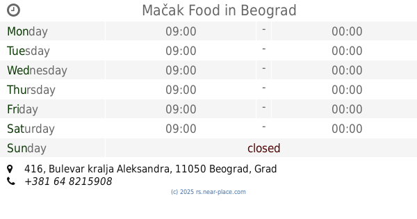
Mačak Food
Bulevar kralja Aleksandra 416, Beograd
Bakery
read more
📑
all categories
Accounting
Administrative area level 2
Airport
Amusement park
Aquarium
Art gallery
Atm
Bakery
Bank
Bar
Beauty salon
Bicycle store
Book store
Bowling alley
Bus station
Cafe
Campground
Car dealer
Car rental
Car repair
Car wash
Casino
Cemetery
Church
City hall
Clothing store
Colloquial area
Convenience store
Courthouse
Dentist
Department store
Doctor
Electrician
Electronics store
Embassy
Establishment
Finance
Fire station
Florist
Food
Funeral home
Furniture store
Gas station
General contractor
Grocery or supermarket
Gym
Hair care
Hardware store
Health
Home goods store
Hospital
Insurance agency
Jewelry store
Laundry
Lawyer
Library
Light rail station
Liquor store
Local government office
Locality
Locksmith
Lodging
Meal delivery
Meal takeaway
Mosque
Movie rental
Movie theater
Moving company
Museum
Natural feature
Neighborhood
Night club
Painter
Park
Parking
Pet store
Pharmacy
Physiotherapist
Plumber
Point of interest
Police
Post office
Premise
Real estate agency
Restaurant
Roofing contractor
Rv park, camping
School
Shoe store
Shopping mall
Spa
Stadium
Storage
Store
Supermarket
Synagogue
Taxi stand
Train station
Transit station
Travel agency
University
Veterinary care
Zoo
administrative area level 3
sublocality level 1
↑