Bank nearby Banka Poštanska Štedionica
Serbia
Bank nearby Banka Poštanska Štedionica
Banka Poštanska Štedionica
Knez Mihailova 54, Beograd 11000 Београд, Beograd 11000, Serbia
contacts phone
:
+381
website:
www.posted.co.rs
Latitude:
44.7866215
, Longitude:
20.4489976
larger map & directions
read more
nearest Bank
691 m
Banca Intesa
Vase Pelagića 48B, Beograd
Bank
read more
711 m
Societe Generale Srbija
Andre Nikolića 2a, Beograd
Bank
read more
788 m
Komercijalna Bank
Andre Nikolića 3, Beograd
Bank
read more
1.195 km
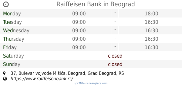
Raiffeisen Bank
Bulevar vojvode Mišića 37, Beograd
Bank
read more
1.206 km
Halkbank
15, 11000, Bulevar vojvode Mišića, Beograd
Bank
read more
1.279 km
Fabrik
Bara Venecija, Belgrade
Bank
read more
1.349 km
Vojvođanska banka
Незнаног јунака 3/а, Beograd
Bank
read more
1.625 km
Eurobank
Sarajevska 69-73, Beograd
Bank
read more
1.869 km
UniCredit Bank
Sarajevska 36, Beograd
Bank
read more
1.873 km
UniCredit Bank
Vojvode Stepe 74, Beograd
Bank
read more
1.913 km
Banca Intesa
Војводе Степе 77 Београд RS
Bank
read more
1.942 km
Poštanska štedionica
Vojvode Stepe 81, Beograd
Bank
read more
1.97 km
Banca Intesa
Sarajevska 27, Beograd
Bank
read more
2.013 km
Комерцијална банка
Savska, Beograd
Bank
read more
2.043 km
Komercijalna banka a.d. Beograd
Vojvode Stepe 103, Beograd
Bank
read more
2.065 km
Crédit Agricol Banka - filijala
Birčaninova 33, Beograd
Bank
read more
2.067 km
VTB Banka a.d. Beograd
Kralja Milutina 57, Beograd
Bank
read more
2.11 km
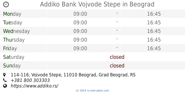
Addiko Bank Vojvode Stepe
Vojvode Stepe 114-116, Beograd
Bank
read more
2.122 km
Addiko Bank
Vojvode Stepe 114-116, Beograd
Bank
read more
2.161 km
Komercijalna
Svetog Save 14, Beograd
Bank
read more
2.185 km
Вип Систем Славија
Bulevar oslobođenja 1, Beograd
Bank
read more
2.201 km
Menjacnica
Nemanjina 36, Beograd
Bank
read more
2.245 km
Menjačnica SLAVIJA (in Hotel Slavija)
Svetog Save 1, Beograd
Bank
read more
2.388 km
Menjačnica Dineros
Beogradska 12, Beograd
Bank
read more
2.427 km
Marfin Bank AD
Beogradska 16, Beograd
Bank
read more
📑
all categories
Accounting
Administrative area level 2
Airport
Amusement park
Aquarium
Art gallery
Atm
Bakery
Bank
Bar
Beauty salon
Bicycle store
Book store
Bowling alley
Bus station
Cafe
Campground
Car dealer
Car rental
Car repair
Car wash
Casino
Cemetery
Church
City hall
Clothing store
Colloquial area
Convenience store
Courthouse
Dentist
Department store
Doctor
Electrician
Electronics store
Embassy
Establishment
Finance
Fire station
Florist
Food
Funeral home
Furniture store
Gas station
General contractor
Grocery or supermarket
Gym
Hair care
Hardware store
Health
Home goods store
Hospital
Insurance agency
Jewelry store
Laundry
Lawyer
Library
Light rail station
Liquor store
Local government office
Locality
Locksmith
Lodging
Meal delivery
Meal takeaway
Mosque
Movie rental
Movie theater
Moving company
Museum
Natural feature
Neighborhood
Night club
Painter
Park
Parking
Pet store
Pharmacy
Physiotherapist
Plumber
Point of interest
Police
Post office
Premise
Real estate agency
Restaurant
Roofing contractor
Rv park, camping
School
Shoe store
Shopping mall
Spa
Stadium
Storage
Store
Supermarket
Synagogue
Taxi stand
Train station
Transit station
Travel agency
University
Veterinary care
Zoo
administrative area level 3
sublocality level 1
↑