Bar nearby Pampour Bar
Serbia
Bar nearby Pampour Bar
Pampour Bar
28, Njegoševa, 11000, Beograd, Grad Beograd, RS Serbia
contacts phone
:
+381 11 3085569
Latitude:
44.8035409
, Longitude:
20.4689274
larger map & directions
read more
nearest Bar
85 m
Caffe Bar Razlog
Alekse Nenadovića, Beograd
Bar
read more
244 m
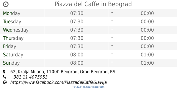
Piazza del Caffe
Kralja Milana 62, Beograd
Bar
read more
253 m
Monk's Bar
71 KNJEGINJE ZORKE, 11104, Belgrade (Vracar), Belgrade county
Bar
read more
302 m
Grill Ranković
Deligradska 1, Beograd
Bar
read more
348 m
Dylan Dog Pub
Svetozara Markovića 24, Beograd
Bar
read more
348 m
Kladionica Meridianbet
Njegoševa 56, Beograd
Bar
read more
417 m
Drvo Javorovo
3, Kneginje Zorke, Beograd
Bar
read more
470 m
klub Manjež - PROSTOR ZA IZNAJMLJIVANJE, PUNOLETSTVA I ŽURKE
49 Svetozara Markovića Београд RS
Bar
read more
507 m
Nixon
11000,, Mišarska, Beograd
Bar
read more
512 m
Mali Vracar
Kursulina 22, Beograd
Bar
read more
582 m
Cveće Zla Deli Wine Bar
Nevesinjska 12, Beograd
Bar
read more
635 m
C Kaffe
Mileševska 3, Beograd
Bar
read more
718 m
Julijana Bar
Pasterova 14 b, Beograd
Bar
read more
723 m
Klub Hores
Кнеза Милоша 9 Београд RS
Bar
read more
778 m
Astra Palace Sportsbar
Macvanska 3 Beograd RS
Bar
read more
816 m
Jazz Rif
Belgrade
Bar
read more
905 m
Džak Bar
Belgrade
Bar
read more
906 m
Rad
Belgrade
Bar
read more
907 m
Grill Ćumur
Bulevar kralja Aleksandra 138, Beograd
Bar
read more
962 m
VRONSKI Cafe&Vin
Internacionalnih brigada 22, Beograd
Bar
read more
973 m
BALKANBET Kladionica
Sarajevska 11, Beograd
Bar
read more
1.011 km
Tavan Beertija
Resavska 88, Beograd
Bar
read more
1.106 km
Cigla & Krigla Pub
Dalmatinska 44, Beograd
Bar
read more
1.125 km
Klub Slika
Dalmatinska, Beograd
Bar
read more
1.204 km
Bum Bum Bar
Belgrade
Bar
read more
📑
all categories
Accounting
Administrative area level 2
Airport
Amusement park
Aquarium
Art gallery
Atm
Bakery
Bank
Bar
Beauty salon
Bicycle store
Book store
Bowling alley
Bus station
Cafe
Campground
Car dealer
Car rental
Car repair
Car wash
Casino
Cemetery
Church
City hall
Clothing store
Colloquial area
Convenience store
Courthouse
Dentist
Department store
Doctor
Electrician
Electronics store
Embassy
Establishment
Finance
Fire station
Florist
Food
Funeral home
Furniture store
Gas station
General contractor
Grocery or supermarket
Gym
Hair care
Hardware store
Health
Home goods store
Hospital
Insurance agency
Jewelry store
Laundry
Lawyer
Library
Light rail station
Liquor store
Local government office
Locality
Locksmith
Lodging
Meal delivery
Meal takeaway
Mosque
Movie rental
Movie theater
Moving company
Museum
Natural feature
Neighborhood
Night club
Painter
Park
Parking
Pet store
Pharmacy
Physiotherapist
Plumber
Point of interest
Police
Post office
Premise
Real estate agency
Restaurant
Roofing contractor
Rv park, camping
School
Shoe store
Shopping mall
Spa
Stadium
Storage
Store
Supermarket
Synagogue
Taxi stand
Train station
Transit station
Travel agency
University
Veterinary care
Zoo
administrative area level 3
sublocality level 1
↑