Cafe nearby Cafe Bar Desanka
Serbia
Cafe nearby Cafe Bar Desanka
Cafe Bar Desanka
Desanke Maksimović, 11000, Beograd, Grad Beograd, RS Serbia
contacts phone
:
+381
Latitude:
44.8069365
, Longitude:
20.4699491
larger map & directions
read more
nearest Cafe
90 m
Super Snack
Beogradska 4, Beograd
Cafe
read more
122 m
Kralj
Bulevar kralja Aleksandra 63, Beograd
Cafe
read more
180 m
Mali Plato
Prote Mateje 60, Beograd
Cafe
read more
267 m
Limbo
Braće Nedić 7, Beograd
Cafe
read more
308 m
Don Juan
Resavska 11, Beograd
Cafe
read more
346 m
Club Tuluz Lotrek
Resavska 24, Beograd
Cafe
read more
593 m
Ambijent cafè
27.Marta 23a, Dvadeset sedmog marta 23a, Beograd
Cafe
read more
689 m
Haos Nargila Cafe
Kraljice Natalije 72, Beograd
Cafe
read more
806 m
Caffe Biblioteka
Далматинска 8 Београд RS
Cafe
read more
834 m
Caffe Frog
Dalmatinska 17, Beograd
Cafe
read more
838 m
Little Prince patisserie
Palmotićeva 27, Beograd
Cafe
read more
923 m
Koki
Makenzijeva 66, Belgrade (Vracar)
Cafe
read more
926 m
Kafeterija Dvorana
Dečanska 14 Belgrade RS
Cafe
read more
941 m
Публин
Lomina 63, Beograd
Cafe
read more
956 m
Kriza Bar
Gavrila Principa 77, Beograd
Cafe
read more
987 m
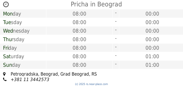
Pricha
Petrogradska, Beograd
Cafe
read more
1.004 km
D'Espresso
Balkanska 2, Beograd
Cafe
read more
1.005 km
Cafeteria Moment
Topolska 16, Beograd
Cafe
read more
1.009 km
Moment
Topolska 16, Beograd
Cafe
read more
1.023 km
Greenet Nusiceva
Nušićeva, Beograd
Cafe
read more
1.033 km
Coffee, Tea and Sympathy
Balkanska 2, Beograd
Cafe
read more
1.05 km
Caffe bar MYSTIC
lokal 62, Чумићево сокаче, Beograd
Cafe
read more
1.18 km
De-Tox The Angle Cafe
Reljina 4 & Kraljice Natalije, Beograd
Cafe
read more
1.206 km
Bife Loznicka 8
Loznička 8, Beograd
Cafe
read more
1.25 km
Monalisa
Maršala Birjuzova 23, Beograd
Cafe
read more
📑
all categories
Accounting
Administrative area level 2
Airport
Amusement park
Aquarium
Art gallery
Atm
Bakery
Bank
Bar
Beauty salon
Bicycle store
Book store
Bowling alley
Bus station
Cafe
Campground
Car dealer
Car rental
Car repair
Car wash
Casino
Cemetery
Church
City hall
Clothing store
Colloquial area
Convenience store
Courthouse
Dentist
Department store
Doctor
Electrician
Electronics store
Embassy
Establishment
Finance
Fire station
Florist
Food
Funeral home
Furniture store
Gas station
General contractor
Grocery or supermarket
Gym
Hair care
Hardware store
Health
Home goods store
Hospital
Insurance agency
Jewelry store
Laundry
Lawyer
Library
Light rail station
Liquor store
Local government office
Locality
Locksmith
Lodging
Meal delivery
Meal takeaway
Mosque
Movie rental
Movie theater
Moving company
Museum
Natural feature
Neighborhood
Night club
Painter
Park
Parking
Pet store
Pharmacy
Physiotherapist
Plumber
Point of interest
Police
Post office
Premise
Real estate agency
Restaurant
Roofing contractor
Rv park, camping
School
Shoe store
Shopping mall
Spa
Stadium
Storage
Store
Supermarket
Synagogue
Taxi stand
Train station
Transit station
Travel agency
University
Veterinary care
Zoo
administrative area level 3
sublocality level 1
↑