Cafe nearby Companeros bar
Serbia
Cafe nearby Companeros bar
Companeros bar
29, Vojvode Šupljikca, Beograd, Grad Beograd, RS Serbia
contacts phone
:
+381
Latitude:
44.8005585
, Longitude:
20.4838956
larger map & directions
read more
nearest Cafe
75 m
Stanica Bistro
Vojvode Šupljikca 19 Beograd RS
Cafe
read more
138 m
Punto Di Caffe Djeram
Bulevar kralja Aleksandra 174, Beograd
Cafe
read more
170 m
Bre Cafe
Radivoja Koraća, Beograd
Cafe
read more
176 m
Plaža U Srcu Grada
Belgrade
Cafe
read more
197 m
Bife Loznicka 8
Loznička 8, Beograd
Cafe
read more
199 m
Pub 23
Kajmakčalanska 1, Beograd
Cafe
read more
217 m
Fresh Cuo
Kajmakčalanska 20, Beograd
Cafe
read more
233 m
La Barrique
Starca Vujadina 19, Beograd
Cafe
read more
473 m
Wine CLUB BLISS
Bulevar kralja Aleksandra, Beograd, Zvezdara
Cafe
read more
507 m
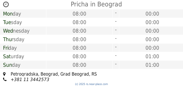
Pricha
Petrogradska, Beograd
Cafe
read more
515 m
Cafeteria Moment
Topolska 16, Beograd
Cafe
read more
518 m
Moment
Topolska 16, Beograd
Cafe
read more
646 m
Zlatni Vilajet
Максима Горког 37, 11000, Beograd
Cafe
read more
771 m
Recoleta
Nevesinjska 21, Beograd
Cafe
read more
788 m
Caffe Bar Eres
Južni bulevar 126, Beograd
Cafe
read more
844 m
Kafeterija
Makenzijeva 81, Beograd
Cafe
read more
886 m
Kitsch Cafe
Ruzveltova 46, Beograd
Cafe
read more
898 m
Caffe Viareggio
Milana Rakića, Beograd
Cafe
read more
903 m
Cafe 9
Bulevar kralja Aleksandra 193, Beograd
Cafe
read more
914 m
Koki
Makenzijeva 66, Belgrade (Vracar)
Cafe
read more
990 m
Pejton Pub
Katanićeva 1, Beograd
Cafe
read more
1.006 km
Kafe Dnevna Soba
Kumanovska 14, Beograd
Cafe
read more
1.042 km
Limbo
Braće Nedić 7, Beograd
Cafe
read more
1.134 km
Mali Plato
Prote Mateje 60, Beograd
Cafe
read more
1.257 km
Kralj
Bulevar kralja Aleksandra 63, Beograd
Cafe
read more
📑
all categories
Accounting
Administrative area level 2
Airport
Amusement park
Aquarium
Art gallery
Atm
Bakery
Bank
Bar
Beauty salon
Bicycle store
Book store
Bowling alley
Bus station
Cafe
Campground
Car dealer
Car rental
Car repair
Car wash
Casino
Cemetery
Church
City hall
Clothing store
Colloquial area
Convenience store
Courthouse
Dentist
Department store
Doctor
Electrician
Electronics store
Embassy
Establishment
Finance
Fire station
Florist
Food
Funeral home
Furniture store
Gas station
General contractor
Grocery or supermarket
Gym
Hair care
Hardware store
Health
Home goods store
Hospital
Insurance agency
Jewelry store
Laundry
Lawyer
Library
Light rail station
Liquor store
Local government office
Locality
Locksmith
Lodging
Meal delivery
Meal takeaway
Mosque
Movie rental
Movie theater
Moving company
Museum
Natural feature
Neighborhood
Night club
Painter
Park
Parking
Pet store
Pharmacy
Physiotherapist
Plumber
Point of interest
Police
Post office
Premise
Real estate agency
Restaurant
Roofing contractor
Rv park, camping
School
Shoe store
Shopping mall
Spa
Stadium
Storage
Store
Supermarket
Synagogue
Taxi stand
Train station
Transit station
Travel agency
University
Veterinary care
Zoo
administrative area level 3
sublocality level 1
↑