Gas station nearby Knez Petrol
Serbia
Gas station nearby Knez Petrol
Knez Petrol
Šalinačka, 230221, Smederevo, Podunavski okrug, RS Serbia
contacts phone
:
+381 64 8056846
website:
www.knezpetrol.com
Latitude:
44.6694626
, Longitude:
20.9393433
larger map & directions
read more
nearest Gas station
493 m
Ferum Petrol
Smederevo
Gas station
read more
1.145 km
NIS Petrol
Đure Daničića, Smederevo
Gas station
read more
1.514 km
Lukoil Gas Station
16. oktobra 86, Smederevo
Gas station
read more
2.037 km
nis
Vojvode Stepe, Smederevo
Gas station
read more
2.039 km
NIS Petrol - Carina
Vojvode Stepe bb, Smederevo
Gas station
read more
2.317 km
OMV
Crvene Armije ББ, Smederevo
Gas station
read more
3.949 km
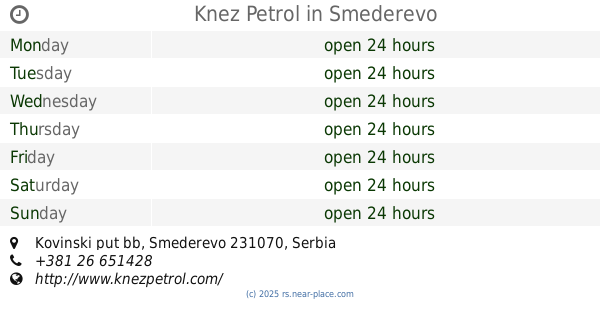
Knez Petrol
Kovinski put bb, Smederevo
Gas station
read more
6.164 km
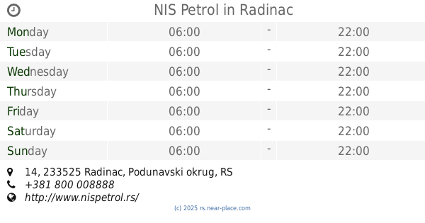
NIS Petrol
14, Radinac
Gas station
read more
36.678 km
Mol
Mokroluška 86, Beograd
Gas station
read more
37.113 km
Fast gas d.o.o. dostava plina
Vojvode Stepe 382, Beograd
Gas station
read more
37.217 km
Avia
Belgrade
Gas station
read more
37.596 km
Gazprom
Bulevar Oslobođenja 343, Beograd
Gas station
read more
38.507 km
MOL
Južni bulevar 87, Beograd
Gas station
read more
38.957 km
NIS Petrol
Mije Kovačevića 7б, Beograd
Gas station
read more
39.84 km
Југопетрол
Vareška, Beograd
Gas station
read more
40.038 km
Еуро Петрол
Viline Vode BB, Beograd
Gas station
read more
40.354 km
Knez Petrol
Oslobođenja 1, Rušanj
Gas station
read more
40.757 km
NIS Petrol
Bul.kralja Aleksandra 632, Beograd
Gas station
read more
41.159 km
Eko Pumpa
Kneza Višeslava 140, Beograd
Gas station
read more
41.284 km
Нис
Раковички пут бб, Београд
Gas station
read more
42.44 km
ART Petrol
Sajmište 29, Beograd
Gas station
read more
42.601 km
Lukoil
Vladimira Popovića, Beograd
Gas station
read more
42.635 km
Gazprom
Trgovačka 74, Beograd
Gas station
read more
42.84 km
Gazprom Petrol – B.S. Novi Beograd Dejton
Bulevar Mihaila Pupina bb Novi Beograd Beograd RS
Gas station
read more
43.163 km
Cryogas Novi Beograd
Savski nasip, Beograd
Gas station
read more
📑
all categories
Accounting
Administrative area level 2
Airport
Amusement park
Aquarium
Art gallery
Atm
Bakery
Bank
Bar
Beauty salon
Bicycle store
Book store
Bowling alley
Bus station
Cafe
Campground
Car dealer
Car rental
Car repair
Car wash
Casino
Cemetery
Church
City hall
Clothing store
Colloquial area
Convenience store
Courthouse
Dentist
Department store
Doctor
Electrician
Electronics store
Embassy
Establishment
Finance
Fire station
Florist
Food
Funeral home
Furniture store
Gas station
General contractor
Grocery or supermarket
Gym
Hair care
Hardware store
Health
Home goods store
Hospital
Insurance agency
Jewelry store
Laundry
Lawyer
Library
Light rail station
Liquor store
Local government office
Locality
Locksmith
Lodging
Meal delivery
Meal takeaway
Mosque
Movie rental
Movie theater
Moving company
Museum
Natural feature
Neighborhood
Night club
Painter
Park
Parking
Pet store
Pharmacy
Physiotherapist
Plumber
Point of interest
Police
Post office
Premise
Real estate agency
Restaurant
Roofing contractor
Rv park, camping
School
Shoe store
Shopping mall
Spa
Stadium
Storage
Store
Supermarket
Synagogue
Taxi stand
Train station
Transit station
Travel agency
University
Veterinary care
Zoo
administrative area level 3
sublocality level 1
↑