Gym nearby Strong Gym
Serbia
Gym nearby Strong Gym
Strong Gym
19, Albanske spomenice, Beograd, Grad Beograd, RS Serbia
contacts phone
:
+381 61 6914639
website:
stronggym.rs
Latitude:
44.8091598
, Longitude:
20.4831706
larger map & directions
read more
nearest Gym
409 m
Tonus fitnes klub Palilula
Zdravka Čelara 14, Beograd
Gym
read more
436 m
Muay Thai Klub Siam
Zdravka Čelara 12, Beograd
Gym
read more
529 m
Beauty studio Simic
Belgrade
Gym
read more
560 m
JUST FIT fitnes studio
Kneza Danila 22, Beograd
Gym
read more
583 m
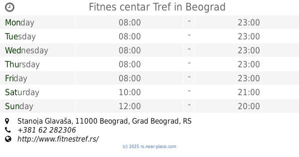
Fitnes centar Tref
25, Stanoja Glavaša, Beograd
Gym
read more
652 m
Contrology Body and Mind Studio
Cvijićeva 46, Beograd
Gym
read more
679 m
Stefan Krstic TVRDJAVA
Mije Kovačevića, Beograd
Gym
read more
684 m
Aerobic & Fitness Club STAR
Vojvode Dobrnjca 50a, Beograd
Gym
read more
734 m
Car Dusan Silni - MMA Beograd - Krav Maga Srbija
Bulevar despota Stefana 115, Beograd
Gym
read more
818 m
Seka salon
Trnska 27, Beograd
Gym
read more
823 m
Pilates professional, Vracar, Beograd (centar)
Hadži-Prodanova 15, Beograd
Gym
read more
840 m
Team FIT Fitness Centar
KNEGINJE ZORKE 96, BEOGRAD, Beograd
Gym
read more
876 m
Sektor A Fitness Centar
Belgrade
Gym
read more
882 m
XL Fitness Factory
RS, 11000, Osmana Đikića 1, Beograd
Gym
read more
913 m
Fitnes 011 1
Bulevar despota Stefana 114, Beograd
Gym
read more
979 m
Vežbalište na otvorenom u parku Tašmajdan
Belgrade
Gym
read more
995 m
Iron Republic Gym
44°49'00. 20°28'36.0"E, Grge Andrijanovića 6. deo, Beograd
Gym
read more
999 m
SOKOLANA climb&fitness
8 Ilije Garašanina Belgrade Serbia
Gym
read more
1.019 km
Fitnes klub Black&White
Takovska 22 Beograd RS
Gym
read more
1.075 km
Tonus fit
Krunska 62, Beograd
Gym
read more
1.118 km
Спин Мастерс
Maksima Gorkog 5, Beograd
Gym
read more
1.168 km
Fitness Tribe
Kneginje Zorke 60, Beograd
Gym
read more
1.185 km
Fizio Gym
Serbia, Baba Višnjina 20, Beograd
Gym
read more
1.227 km
GoActive Goati
Palmotićeva 26, Beograd
Gym
read more
1.239 km
Fitnes Centar Andjela
Molerova 27, Beograd
Gym
read more
📑
all categories
Accounting
Administrative area level 2
Airport
Amusement park
Aquarium
Art gallery
Atm
Bakery
Bank
Bar
Beauty salon
Bicycle store
Book store
Bowling alley
Bus station
Cafe
Campground
Car dealer
Car rental
Car repair
Car wash
Casino
Cemetery
Church
City hall
Clothing store
Colloquial area
Convenience store
Courthouse
Dentist
Department store
Doctor
Electrician
Electronics store
Embassy
Establishment
Finance
Fire station
Florist
Food
Funeral home
Furniture store
Gas station
General contractor
Grocery or supermarket
Gym
Hair care
Hardware store
Health
Home goods store
Hospital
Insurance agency
Jewelry store
Laundry
Lawyer
Library
Light rail station
Liquor store
Local government office
Locality
Locksmith
Lodging
Meal delivery
Meal takeaway
Mosque
Movie rental
Movie theater
Moving company
Museum
Natural feature
Neighborhood
Night club
Painter
Park
Parking
Pet store
Pharmacy
Physiotherapist
Plumber
Point of interest
Police
Post office
Premise
Real estate agency
Restaurant
Roofing contractor
Rv park, camping
School
Shoe store
Shopping mall
Spa
Stadium
Storage
Store
Supermarket
Synagogue
Taxi stand
Train station
Transit station
Travel agency
University
Veterinary care
Zoo
administrative area level 3
sublocality level 1
↑