Restaurant nearby Mica Pro
Serbia
Restaurant nearby Mica Pro
Mica Pro
23, Stevana Kaćanskog, Niš, Nišavski okrug, RS Serbia
contacts phone
:
+381
Latitude:
43.3139015
, Longitude:
21.8839811
larger map & directions
read more
nearest Restaurant
201 m
Na Jedno Mesto
Obilićev Venac 113, Niš
Restaurant
read more
242 m
Amfora
104 OBILICEV VENAC, 18000, Nis, Nisavski county, Niš
Restaurant
read more
533 m
Val & Go - Go
Jovana Ristića 11, Niš
Restaurant
read more
593 m
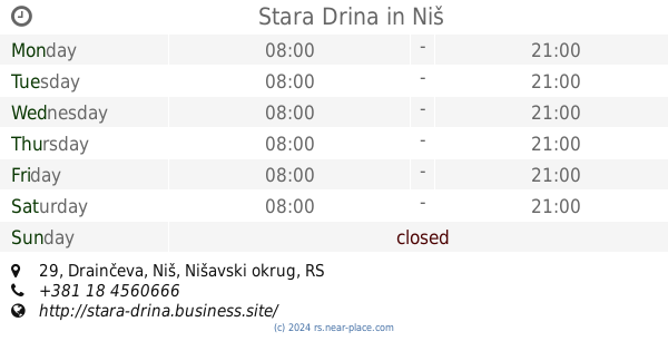
Stara Drina
Drainčeva 29, Niš
Restaurant
read more
603 m
Zlatni grb
Generala Milojka Lešjanina 70, Niš
Restaurant
read more
644 m
THE CHICHEN FOOD
Trg Kralja Aleksandra Ujedinitelja, Niš
Restaurant
read more
697 m
Pasta Bar 2x2
Sokolska 1, Niš
Restaurant
read more
728 m
Pekara Žitopek
Trg Kralja Aleksandra Ujedinitelja, Niš
Restaurant
read more
912 m
Prince
Ivana Milutinovića 28, Niš
Restaurant
read more
933 m
King Baker
Nikole Pašića 34, Niš
Restaurant
read more
1.012 km
Pleasure Center
Drvarska 2, Niš
Restaurant
read more
1.083 km
Нишка колиба
Niš
Restaurant
read more
1.089 km
Етно Кућа
Skopljanska, Niš
Restaurant
read more
1.096 km
Regent Club
Generala Milojka Lešjanina 7, Niš
Restaurant
read more
1.12 km
L' Avenue 22 Café & Restaurant
Obrenovićeva 22, Niš
Restaurant
read more
1.137 km
Queens
Kej Mike Paligorića, Niš
Restaurant
read more
1.17 km
Fast Food Emy
14 A SVETOSAVSKA, 18000, Nis, Nisavski county
Restaurant
read more
1.188 km
Fresco Pizza Bar
Davidova 9, Ниш, Србија Nis RS
Restaurant
read more
1.217 km
McDonald’s
Generala Milojka Lešjanina 2, Niš
Restaurant
read more
1.222 km
Zoki I Nena
Trg kralja Milana 1, Niš
Restaurant
read more
1.245 km
Novopazarski Cevap Deset Upola
Trg kralja Milana 9-11, Niš
Restaurant
read more
1.29 km
Ambasador Hotel
Vožda Karađorđa 2, Niš
Lodging
Restaurant
Point of interest
Food
Establishment
read more
1.324 km
Pekara Žitopek
Vožda Karađorđa 7, Niš
Restaurant
read more
1.367 km
Leskovački Roštilj
Đuke Dinić, Niš
Restaurant
read more
1.827 km
Нишлијска механа
Prvomajska 49, Niš
Restaurant
read more
📑
all categories
Accounting
Administrative area level 2
Airport
Amusement park
Aquarium
Art gallery
Atm
Bakery
Bank
Bar
Beauty salon
Bicycle store
Book store
Bowling alley
Bus station
Cafe
Campground
Car dealer
Car rental
Car repair
Car wash
Casino
Cemetery
Church
City hall
Clothing store
Colloquial area
Convenience store
Courthouse
Dentist
Department store
Doctor
Electrician
Electronics store
Embassy
Establishment
Finance
Fire station
Florist
Food
Funeral home
Furniture store
Gas station
General contractor
Grocery or supermarket
Gym
Hair care
Hardware store
Health
Home goods store
Hospital
Insurance agency
Jewelry store
Laundry
Lawyer
Library
Light rail station
Liquor store
Local government office
Locality
Locksmith
Lodging
Meal delivery
Meal takeaway
Mosque
Movie rental
Movie theater
Moving company
Museum
Natural feature
Neighborhood
Night club
Painter
Park
Parking
Pet store
Pharmacy
Physiotherapist
Plumber
Point of interest
Police
Post office
Premise
Real estate agency
Restaurant
Roofing contractor
Rv park, camping
School
Shoe store
Shopping mall
Spa
Stadium
Storage
Store
Supermarket
Synagogue
Taxi stand
Train station
Transit station
Travel agency
University
Veterinary care
Zoo
administrative area level 3
sublocality level 1
↑