Restaurant nearby Zavičaj
Serbia
Restaurant nearby Zavičaj
Zavičaj
77, Gavrila Principa, Beograd, Grad Beograd, RS Serbia
contacts phone
:
+381 63 369670
website:
www.zavicaj.rs
Latitude:
44.809259
, Longitude:
20.458634
larger map & directions
read more
nearest Restaurant
29 m
BurgerCraft Beograd
60a, Gavrila Principa, Beograd
Restaurant
read more
32 m
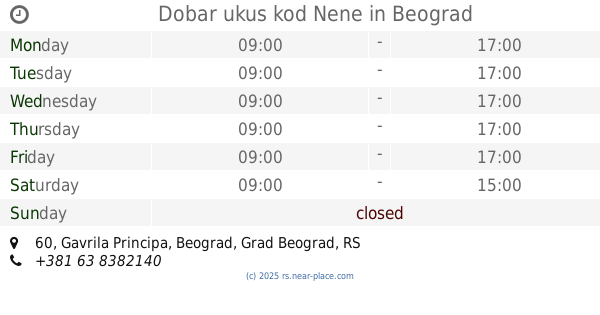
Dobar ukus kod Nene
Gavrila Principa 60, Beograd
Restaurant
read more
42 m
Grill Balkanska
Balkanska 45, Beograd
Restaurant
read more
101 m
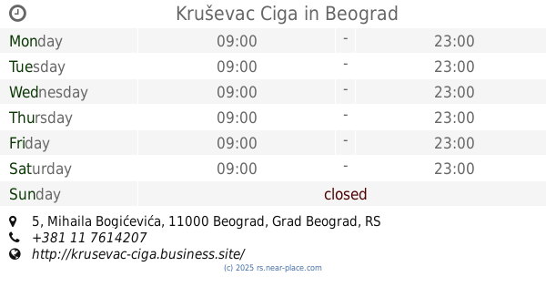
Kruševac Ciga
Mihaila Bogićevića 5, Beograd
Restaurant
read more
102 m
Maximilian Curry&Scampi
29 BALKANSKA, 11040, Belgrade (Savski Venac), Belgrade county
Restaurant
read more
112 m
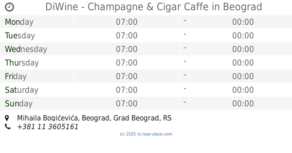
DiWine - Champagne & Cigar Caffe
Mihaila Bogićevića, Beograd
Restaurant
read more
135 m
Giros tim
Balkanska 36, Beograd
Restaurant
read more
150 m
Gastroteka
Belgrade
Restaurant
read more
159 m
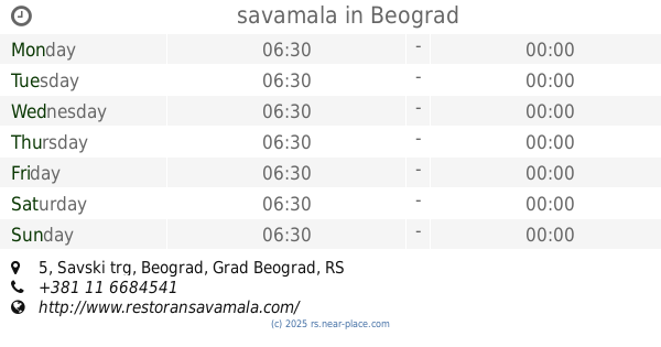
savamala
Savski trg 5, Beograd
Restaurant
read more
161 m
Oshjosh
Balkanska 26, Beograd
Restaurant
read more
164 m
Zajedno
Kraljice Natalije 38, Beograd
Restaurant
read more
175 m
IQ CAFE
Kraljice Natalije 54, Beograd
Restaurant
read more
186 m
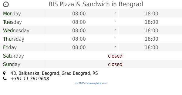
BIS Pizza & Sandwich
Balkanska 48, Beograd
Restaurant
read more
219 m
Restoran Stanica 1884
Savski Trg 2 Beograd RS
Restaurant
read more
223 m
Коку Пилетина и Роштиљ
Nemanjina 1, Beograd
Restaurant
read more
294 m
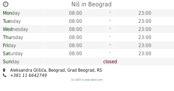
Niš
Aleksandra Glišića, Beograd
Restaurant
read more
320 m
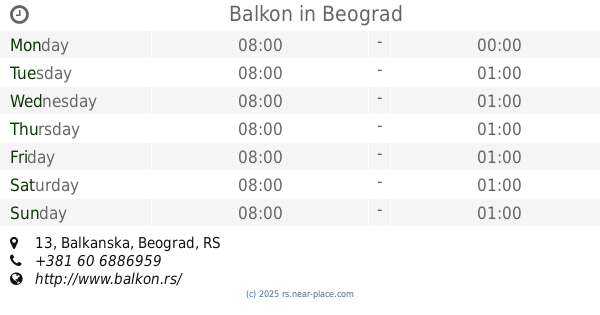
Balkon
Balkanska 13, Beograd
Restaurant
read more
636 m
Mikan Restaurant
Maršala Birjuzova 14, Beograd
Restaurant
read more
689 m
Disco Grill Radost
Karađorđeva 44, Beograd
Restaurant
read more
852 m
Megapolis Kafe Restoran
Čika-Ljubina, Beograd
Restaurant
read more
918 m
Hot-Sis
16 CIKA LJUBINA, 11102, Belgrade (Stari Grad), Belgrade county
Restaurant
read more
927 m
Good Appetite
7,, Vase Čarapića, Beograd
Restaurant
read more
951 m
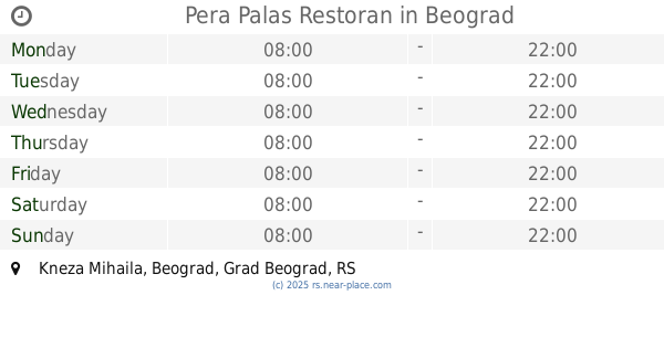
Pera Palas Restoran
Kneza Mihaila, Beograd
Restaurant
read more
974 m
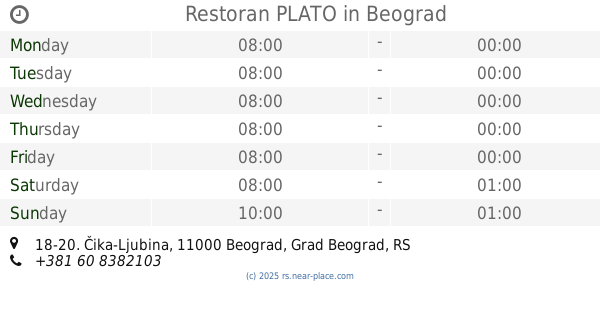
Restoran PLATO
Čika-Ljubina 18-20, Beograd
Restaurant
read more
1.062 km
Једно место
Cetinjska 15, Beograd
Restaurant
read more
📑
all categories
Accounting
Administrative area level 2
Airport
Amusement park
Aquarium
Art gallery
Atm
Bakery
Bank
Bar
Beauty salon
Bicycle store
Book store
Bowling alley
Bus station
Cafe
Campground
Car dealer
Car rental
Car repair
Car wash
Casino
Cemetery
Church
City hall
Clothing store
Colloquial area
Convenience store
Courthouse
Dentist
Department store
Doctor
Electrician
Electronics store
Embassy
Establishment
Finance
Fire station
Florist
Food
Funeral home
Furniture store
Gas station
General contractor
Grocery or supermarket
Gym
Hair care
Hardware store
Health
Home goods store
Hospital
Insurance agency
Jewelry store
Laundry
Lawyer
Library
Light rail station
Liquor store
Local government office
Locality
Locksmith
Lodging
Meal delivery
Meal takeaway
Mosque
Movie rental
Movie theater
Moving company
Museum
Natural feature
Neighborhood
Night club
Painter
Park
Parking
Pet store
Pharmacy
Physiotherapist
Plumber
Point of interest
Police
Post office
Premise
Real estate agency
Restaurant
Roofing contractor
Rv park, camping
School
Shoe store
Shopping mall
Spa
Stadium
Storage
Store
Supermarket
Synagogue
Taxi stand
Train station
Transit station
Travel agency
University
Veterinary care
Zoo
administrative area level 3
sublocality level 1
↑