Bar nearby Petlja Bar
Serbia
Bar nearby Petlja Bar
Petlja Bar
А1, Beograd, Grad Beograd, RS Serbia
contacts phone
:
+381 66 250025
website:
www.facebook.com
Latitude:
44.7987363
, Longitude:
20.4485024
larger map & directions
read more
nearest Bar
685 m
Kladionica Meridianbet
Sarajevska 47, Beograd
Bar
read more
687 m
Tavan Beertija
Resavska 88, Beograd
Bar
read more
951 m
BALKANBET Kladionica
Sarajevska 11, Beograd
Bar
read more
999 m
Princip Pub 3
Ruska 1, Beograd
Bar
read more
1.041 km
Da rezervisem - LASTA splav Club - Beograd
Sajamski kej bb Beograd RS
Bar
read more
1.13 km
Mrs & Mood
Nemanjina 4, Beograd
Bar
read more
1.282 km
Da rezervisem - BLAYWATCH Splav - Beograd
Staro Sajmište, Belgrade
Bar
read more
1.44 km
Drvo Javorovo
3, Kneginje Zorke, Beograd
Bar
read more
1.487 km
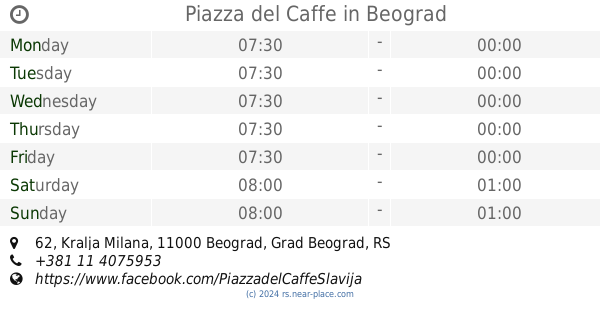
Piazza del Caffe
Kralja Milana 62, Beograd
Bar
read more
1.691 km
VRONSKI Cafe&Vin
Internacionalnih brigada 22, Beograd
Bar
read more
1.698 km
Pampour Bar
11000 11000, Njegoševa 28, Beograd
Bar
read more
1.721 km
TAMAN.D59B
Karađorđeva 44, Beograd
Bar
read more
1.735 km
Caffe Bar Razlog
Alekse Nenadovića, Beograd
Bar
read more
1.782 km
Bar-A-Bar
Bulevar Oslobođenja 75, Beograd
Bar
read more
1.93 km
Monk's Bar
71 KNJEGINJE ZORKE, 11104, Belgrade (Vracar), Belgrade county
Bar
read more
1.967 km
Egoiste Deli & Bistro
Petra Kočića 12, Beograd
Bar
read more
1.97 km
Detox kuhinjica Juice bar
Belgrade
Bar
read more
1.995 km
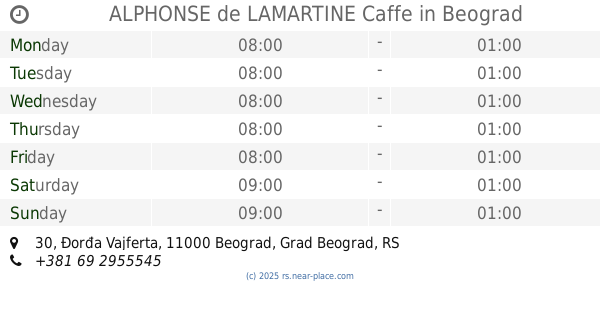
ALPHONSE de LAMARTINE Caffe
Đorđa Vajferta 30, Beograd
Bar
read more
1.995 km
zaDa rezervisem - ALPHONSE de LAMARTINE Caffe
Đorđa Vajferta 30, Beograd
Bar
read more
1.996 km
Cveće Zla Deli Wine Bar
Nevesinjska 12, Beograd
Bar
read more
2.003 km
Pivopija
Belgrade
Bar
read more
2.033 km
Bada Bing
Belgrade
Bar
read more
2.081 km
Љутица Бар
Ljutice Bogdana 32, Beograd
Bar
read more
2.452 km
85 BAR
Antifašističke borbe 33, Beograd
Bar
read more
2.592 km
Luft Cafe
Požeška 10, Beograd
Bar
read more
📑
all categories
Accounting
Administrative area level 2
Airport
Amusement park
Aquarium
Art gallery
Atm
Bakery
Bank
Bar
Beauty salon
Bicycle store
Book store
Bowling alley
Bus station
Cafe
Campground
Car dealer
Car rental
Car repair
Car wash
Casino
Cemetery
Church
City hall
Clothing store
Colloquial area
Convenience store
Courthouse
Dentist
Department store
Doctor
Electrician
Electronics store
Embassy
Establishment
Finance
Fire station
Florist
Food
Funeral home
Furniture store
Gas station
General contractor
Grocery or supermarket
Gym
Hair care
Hardware store
Health
Home goods store
Hospital
Insurance agency
Jewelry store
Laundry
Lawyer
Library
Light rail station
Liquor store
Local government office
Locality
Locksmith
Lodging
Meal delivery
Meal takeaway
Mosque
Movie rental
Movie theater
Moving company
Museum
Natural feature
Neighborhood
Night club
Painter
Park
Parking
Pet store
Pharmacy
Physiotherapist
Plumber
Point of interest
Police
Post office
Premise
Real estate agency
Restaurant
Roofing contractor
Rv park, camping
School
Shoe store
Shopping mall
Spa
Stadium
Storage
Store
Supermarket
Synagogue
Taxi stand
Train station
Transit station
Travel agency
University
Veterinary care
Zoo
administrative area level 3
sublocality level 1
↑